For some reason I thought this site would be easy to find. I remember being amazed when I first heard about it, and that it was only (re)discovered in 1986. Since then I have read about it several times, and day dreamed about seeing it many more. Why ?
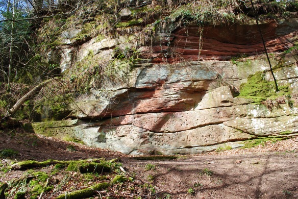
 Because it comprises a significant concentration of prehistoric rock art (which I always love seeing !) and in contrast to many others I have seen (which are usually on more horizontal or sloping outcrops of rock) I knew it was an almost unique example of prehistoric rock art on a vertical cliff face. It is special and I could not wait to finally meet this site…
but in my haste (and arrogance not checking my map properly first !) I found myself plunged into a world comprising river gorges and quarries: a startling blend of natural habitat and cultural legacy.
 On the rock faces, are modern embellishments,
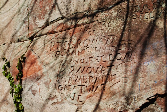
 Poignant, earlier commemorations, with at least two inscriptions, to soldiers from the Gordon Highlanders,
 And hints at possible earlier activity* leaving marks on the rock…
 *the grooved lines are reminiscent of a Polissoir (a rock used for polishing stone axe heads c 5500 years ago) but of course there may be other explanations !
As well as this variety of signs marking the red sandstone cliff faces, a more substantial legacy of past activity can readily be found. Testimony to when, lines torn across our landscapes, great iron beasts spewing smoke needed to span the gorge of the River Ayr. Still dominating one portion of the river gorge is the Ballochmyle Viaduct (when constructed the widest stone arch in the world) which was built between 1846 and 1848 to take the Glasgow to Carlisle (Nithsdale) railway line.
 It is largely built of red sandstone quarried from nearby. In amongst the woodlands, you can find the substantial vertical walled spaces from which these sandstone blocks were quarried.
 The more I looked amongst the sides of the gorge, the more I saw vertical faces in the rock which I thought were an ideal location for prehistoric rock art.
 But alas no. In defeat, I returned to the car and succumbed to modern technology, checking on my phone the CANMORE entry for the site: which confirmed my growing suspicion that it was only a stones throw from where I had parked the car !
So finally


 Take it for read that the prehistoric rock art motiffs (approximately c 5500 – 4500 years old) are remarkable…! Following my earlier exploration, more striking, however, was the landscape context of the rock art and the evidence for later embellishment.
In terms of evidence for later activity at the site, intriguingly it has been noted by JG Stevenson that there is another partially legible inscription ‘…ASAID’ over the prehistoric rock art. Intriguing because it is suggested that the inscription is in a raised Lombardic-style of writing, which implies it is Medieval in date. There are also carvings thought to be figures of deer which may also be Medieval. Stevenson also noted that there is an inscription of 1751 on one rock panel. He wonders if clearly visited in the 18th century why the site was not known to antiquarians (and lost till 1986): but the stone remembers two previous visits to the site.
My visit left no trace but my exploration of the wider landscape in which the rock art panels are situated meant I departed with a very different understanding than if had I simply gone straight to them. Before I visited, I knew the rock art at Ballochmyle was in striking contrast to many other examples from Scotland (which are often on hill sides with more open views.) I could readily see from maps that Ballochmyle was situated up a minor tributary off a significant river, but as it now easily reached from a main road most people will encounter the site in this way. If, however, approached by a river side journey (as may well have occurred in the past) the choice of location makes more sense. The drama of approaching the gorge, of traveling into a place where the light, sound and humidity is different. A place with different levels of seasonal water flow may have been dangerous and difficult to navigate.
 You then had to know (or be shown) where to leave the river side to follow up a minor tributary to reach the location of the rock art. Only then might you be allowed to view it. What you could immediately see would depend on what time of day as the southern panel is on a dogleg, and partially separated by projection of rock, from the northern section: resulting in times when one side could be in sunlight and the other in shadow. Perhaps if the light condition across the rock faces was deemed appropriate that was what determined whether you could add to the memories already inscribed in cup and ring markings many times before. Only then, the sound of carving, stone striking stone, may have ricochet and echoed down amongst the stone faces of the gorge.
In the 19th century, there was another sound as the quarries crept closer to the rock art panels. There is only a distance of a few meters from the quarry face and where the Ballochmyle rock art (it could so easily have been taken away) had remained for over four thousand years. Those working the quarry would undoubtedly have seen and respected the traces of memories on these stones but they appear to have kept quiet about them.
 Still the River Ayr continues its journey, the murmur of water leaping and splashing, carving slowly deeper with time as it meanders through the old red sandstone. A place of memories, sometimes forgotten by people, but the stone remembers…
——————————————————————————————————————-
The Glasgow Archaeological Society publication on Ballochmyle by Jack Stevenson ‘Cup-and-Ring Markings at Ballochmyle, Ayrshire’ can be found free on the EUP website.
The location of some of the sandstone quarries can be seen on the First Edition Ordnance Survey Map (surveyed in 1856; published in 1860) from the National Library digital map collection. There is also a ‘Summer House’ marked in the woodland amongst a network of paths. On the Second Edition Ordnance Survey Map, (re-surveyed in 1908; published in 1909) the one closest to the rock art is annotated ‘Old Quarry’ suggesting it is no longer being used and the one closest to the viaduct has expanded, suggesting a deliberate avoidance of removing the rock art via quarrying in the later part of the 19th century.
